
GeoMate Inc
When: June, 2025
* Dates are subject to change
Where: Virtual demonstration.
Targeted area: Urban areas in Vaughan (TBC)
Project Partner:
- City of Vaughan • Infrastructure Planning and Corporate Asset Management – Active Transportation
- City of Vaughan • Public Works – Transportation and Fleet Management Services (MoveSmart, Traffic Engineering)

Aerial Vision HD Mapping Solution
The City of Vaughan is committed to creating a walkable, bikeable and interconnected environment. By investing in safe and connected infrastructure for all modes of transportation, the City aims to provide viable active transportation options, accommodate micromobility users and free up road space for those who must drive to get to where they are going.
To effectively plan and maintain infrastructure projects, City staff need accurate and up-to-date imaging and asset data. Currently, infrastructure assessments rely on outdated aerial images and manual inspections, which can be time-consuming and resource intensive.
This demonstration will assess how artificial intelligence can utilize high-definition imagery to take inventory of city assets, measure and identify inconsistencies in public right of way and alert users of gaps and maintenance needs. This can effectively support City staff in projects involving design and implementation, active transportation, infrastructure inventory, and transportation planning. The demonstration will be operated remotely, with field inspections conducted for data verification.
Purpose:
The purpose of this demonstration is to evaluate the accuracy and effectiveness of using AI-driven tools to:
- Identify infrastructure gaps, such as sidewalks and cycling networks
- Take inventory of infrastructure such as signages and pavement markings
Expected Outcomes:
- A map that shows infrastructure gaps in accessibility of different networks and identifies opportunities for inter-network connections
- Asset Inventory of signage and pavement markings
Company Description:
Waterloo, Ontario – GeoMate, a leading location intelligence company, is transforming the landscape of geospatial data analytics with its advanced AI-driven mapping solutions. Dedicated to enhancing urban mobility, GeoMate provides a more accurate, scalable, and cost-effective alternative to traditional HD mapping methods.
For over five years, GeoMate has been at the forefront of geospatial innovation, developing an autonomous GIS data extraction system designed to map city transportation networks with unparalleled precision. By integrating high-resolution geospatial imagery with artificial intelligence, GeoMate delivers highly detailed HD maps tailored for autonomous driving (AD), advanced driver-assistance systems (ADAS), and urban planning.
GeoMate’s cutting-edge technology not only reduces the time and costs associated with map creation but also plays a crucial role in advancing smart mobility. Its solutions support cities and industries in building sustainable, connected, and automated transportation networks—paving the way for the future of mobility.
HD Map-Making
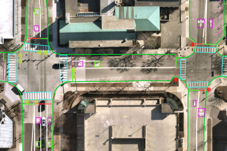
GeoMate's computer vision technology uses AI to autonomously map 35+ features of the captured built environment.
About Aerial Vision HD Mapping Solutions
GeoMate's technology applies their AI software to aerial images and analyzes gaps in transportation networks.
The process begins with high-resolution aerial images that form the basis of their datasets. Then, using cutting-edge computer vision technology, the AI detects and maps more than 35 features through its trained detection. Human verification occurs where required. This information is then employed to construct high-definition maps.
GeoMate's solution is also designed to be highly accurate, achieving precision up to 10 cm, while supporting various data formats for seamless integration into different systems.
No personal data will be collected with this technology demonstration.
The City will share aggregated and anonymized data about road networks and infrastructure, such as transportation routes (cycle lane networks), and the standards for signs, pavement markings, or curbs and sidewalks. This demonstration project may help identify potential gaps in our transportation networks and improve road conditions for all users.
GeoMate's geospatial mapping technology can enhance the inventory and planning of infrastructure for the City. Machine learning algorithms can rapidly analyze data to determine the optimal locations for new infrastructure, record existing assets, and identify gaps within the transportation network. Ultimately, this data-driven approach empowers planners to make precise, sustainable, and equitable decisions. Additionally, the aerial images are taken more frequently and provides the City could have updated mapping for the maintenance and planning of their roadway infrastructure.
The data will be used to identify gaps in the transportation network, evaluate the conditions and types of infrastructure assets, and inform maintenance and improvements decisions.